Volcanic activity, a profound expression of Earth's internal dynamics, is fundamentally driven by the movement of tectonic plates and localized hot spots. These geological processes dictate where volcanoes form and influence their characteristic eruption styles, which in turn determine the specific hazards they pose. From the gentle flows of shield volcanoes to the explosive power of stratovolcanoes and the catastrophic potential of calderas, each type presents distinct risks.
To mitigate these dangers, volcanologists employ a sophisticated array of monitoring techniques. By continuously tracking a volcano's "vital signs," scientists can detect subtle changes that may signal an impending eruption or other hazardous events, providing crucial information for hazard assessment and public safety.
The Geological Engines of Volcanism
The vast majority of Earth's volcanoes are intimately linked to plate tectonics, the scientific theory describing the large-scale motion of Earth's lithosphere. The Earth's outer shell is broken into several large plates that are constantly moving, interacting at their boundaries. These interactions—divergence, convergence, and transform motion—are the primary drivers of volcanic activity.
At divergent plate boundaries, where plates pull apart, magma rises from the mantle to fill the gap, creating new crust and often forming mid-ocean ridges and associated volcanoes. Convergent plate boundaries, where plates collide, are responsible for some of the most explosive volcanoes. Here, one plate is typically forced beneath another in a process called subduction. As the subducting plate descends, it melts, and the resulting magma rises to the surface, forming volcanic arcs.
Beyond plate boundaries, some volcanoes form over "hot spots," which are areas where plumes of hot mantle material rise to the surface. These hot spots can occur beneath both oceanic and continental crust, creating chains of volcanoes as the tectonic plate moves over the stationary plume. The Hawaiian Islands, for example, are a classic illustration of hot spot volcanism.
Comparing Major Volcano Types, Eruption Styles, and Hazards
Volcanoes are broadly categorized into several types, each with characteristic eruption styles and associated hazards. Understanding these distinctions is crucial for assessing potential risks and informing hazard mitigation strategies.
| Volcano Type | Characteristic Eruption Style | Associated Hazards |
|---|---|---|
| Stratovolcano (Composite Volcano) | These volcanoes typically produce explosive eruptions. | Hazards include explosive eruptions, ashfall, and pyroclastic flows. |
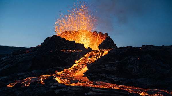
| Shield Volcano | Shield volcanoes are characterized by effusive eruptions, producing fluid lava flows. | Primary hazards are extensive lava flows that can cover large areas. |
| Caldera | Calderas are formed by massive, often catastrophic, caldera-forming eruptions. | Hazards include widespread ashfall, pyroclastic flows, and potential for global climate impact. |
Beyond these primary eruption characteristics, each volcano type can also generate other phenomena. The U.S. National Park Service notes that all volcano types can produce lava flows, eruption columns of ash and tephra, lahars, or pyroclastic flows. Lahars, for instance, are fast-moving volcanic debris flows composed mainly of water, ash, and rock fragments. These flows, which can have the consistency of cement and the speed of a fast-moving river, are particularly associated with steep-sided volcanoes and can occur during an eruption or in response to heavy rainfall, as Christopher Keane of the AGI Geoscience Profession explains.
Pyroclastic flows, another significant hazard, consist of hot gases, ash, and rock fragments that can travel at high speeds down volcanic slopes. These flows are extremely destructive and can incinerate everything in their path. The U.S. National Park Service also points out that volcanic hazards are not limited to active eruption periods. Volcanic mountains can be inherently unstable, making them prone to landslides at any time. Furthermore, hydrothermal areas, fumaroles, and certain gas emissions present hazards even when a volcano is otherwise quiet, potentially leading to acid rain or volcanic smog (vog).
Monitoring Volcanic Activity for Hazard Assessment
Volcanologists continuously monitor volcanoes to detect changes that might signal an impending eruption or other hazardous activity. This monitoring involves tracking several "vital signs" of a volcano, which can indicate magma movement or pressure changes beneath the surface. The U.S. National Park Service highlights several key monitoring techniques:
-
Seismology (Earthquake Activity): Monitoring seismic activity is a primary method for detecting magma movement. As magma moves beneath a volcano, it can fracture rock, generating earthquakes. An increase in the frequency, intensity, or location of these earthquakes can indicate that magma is rising or shifting within the volcanic edifice. This data helps scientists pinpoint the depth and path of magma.
-
Ground Deformation: Changes in the shape of a volcano's surface can signal the accumulation or withdrawal of magma. Instruments such as tiltmeters, GPS receivers, and satellite-based radar (InSAR) measure subtle swelling, shrinking, or shifting of the ground. Inflation of the ground often suggests magma is pushing upwards, causing the volcano to bulge, while deflation might indicate magma is moving away or has erupted. These measurements provide critical insights into the pressure changes within the magma chamber.
-
Gas Emissions: Volcanoes release various gases, including sulfur dioxide, carbon dioxide, and water vapor. Changes in the composition, quantity, or temperature of these gases can provide clues about the type and depth of magma, as well as its ascent rate. Increased gas emissions or changes in gas ratios can precede an eruption, as rising magma releases dissolved gases. Monitoring these emissions helps assess the volcano's internal state.
-
Hydrologic Activity: Monitoring changes in water levels, temperature, and chemistry in volcanic lakes and hot springs can also provide insights into volcanic unrest. Magma interacting with groundwater can alter these parameters, indicating increased heat flow or gas release. For example, a sudden increase in the temperature or acidity of a volcanic lake could signal rising magma or increased hydrothermal activity.
-
Slope Instability: Volcanic slopes can become unstable due to internal pressure changes, seismic activity, or heavy rainfall, leading to landslides or debris flows. Monitoring the stability of these slopes helps assess the risk of such events, which can occur independently of an eruption but still pose significant hazards to surrounding areas. Instruments like extensometers and tiltmeters can help detect subtle movements on the slopes.
The U.S. Geological Survey (USGS) Volcano Hazards Program emphasizes that its observatories monitor, research, and issue notices for volcanoes within their assigned areas. This comprehensive approach aims to enhance public safety through forecasts, warnings, and hazard assessments. By integrating data from these diverse monitoring techniques, scientists can develop a more complete picture of a volcano's behavior and provide timely warnings to communities at risk.
Staying Informed: Monitoring Volcanic Activity for Safety
Understanding the distinct characteristics of different volcano types and the scientific methods used to monitor them is crucial for appreciating the complexities of volcanic hazards. For individuals living near or visiting volcanically active regions, the decision is to regularly consult official volcano hazard programs and advisories for areas of interest. A measurable indicator of the need for action or increased vigilance is changes in official alert levels or issuance of new warnings from geological survey organizations.