No single instrument can watch the ocean's chemistry change. Scientists monitor ocean acidification by combining three platform types—satellites that scan entire ocean basins from orbit, uncrewed aerial vehicles that capture fine local detail, and in-situ instruments such as moored buoys and research ships that measure seawater chemistry directly. Each answers a question the others cannot: satellites provide breadth, drones provide resolution, and buoys and ships provide ground truth. Understanding the trade-offs among them explains how researchers assemble a global picture of a problem that unfolds unevenly across space and time.
Satellites: Broad Views from Above
Satellites deliver what no other platform can: synoptic, repeatable coverage of the ocean surface on a global scale. As Olga Anghelici reported in a 2023 article on satellite monitoring of ocean acidity, space-based instruments measure the pH of surface waters and atmospheric carbon dioxide concentrations, and they also track sea surface temperature and salinity—factors that influence how the ocean absorbs CO2 and how acidity develops.
Crucially, though, most of this is inference rather than direct measurement. A review of remote-sensing observations relevant to ocean acidification, indexed in the EPA's HERO database, summarizes the products satellites can actually deliver: air-sea CO2 fluxes, total alkalinity, suspended calcite (particulate inorganic carbon), particulate organic carbon, and calcification rates. These are used to observe acidification indirectly, and the review is blunt about the catch: "Confounding factors and limitations of algorithms are major sources of errors."
Real studies show how this works in practice. One analysis of carbonate chemistry drew on MODIS-Aqua remote-sensing data—reflectance, chlorophyll, and sea surface temperature at 4 km resolution—combined with reanalysis products for the period 2004–2019, and validated the results against in-situ measurements of total alkalinity and pH from the GLODAP dataset spanning 1992 to 2019. A demonstration in the Greater Caribbean Region, described in the journal Oceanography, likewise relied on regionally specific empirical algorithms derived from ongoing ship measurements and applied to remotely sensed observables. The satellite sees the surface; the chemistry is modeled from what it sees.
UAVs: High-Resolution Local Insights
Uncrewed aerial vehicles occupy the opposite end of the scale spectrum. A 2026 review of multi-scale remote sensing for water quality, published in Frontiers in Environmental Science by Diandian Xu, Zongpu Xue, Lumiao Hu, and Huaimin Chen, notes that UAV-based remote sensing carries strong potential for small-scale water body monitoring. In one comparison the authors cite, three sensors at very different spatial resolutions—10 m, 30 m, and 8 cm—showed strong correlations, with the UAV delivering the finest detail by far.
That resolution comes at a price. The same review finds that although UAVs generally offer higher spectral and spatial resolution than satellite sensors, their application is constrained by flight duration, weather conditions, and the demanding data acquisition needed to produce high-quality orthomosaic products. A drone can be deployed on demand for a specific event or campaign, but it cannot linger for months or cross an ocean basin.
One caveat belongs here: the strongest UAV evidence comes from inland water quality monitoring, not open-ocean acidification work. The operational lessons—flexible deployment, centimeter-scale imagery, tight limits on endurance and range—transfer by analogy to coastal and nearshore ocean studies, where drones can bridge the gap between a satellite's coarse pixel and a buoy's single point.
In-Situ Instruments: Precision at the Source
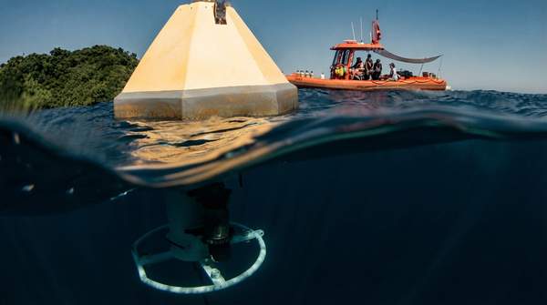
Buoys and ships are the backbone of acidification monitoring because they measure the water itself. NOAA's Ocean Acidification Program describes moored buoys that remain stationary and deliver continuous, real-time measurements from the same location over time—time series that are, in the program's words, "key to understanding how ocean chemistry is changing over time." Buoys are moored in the open ocean and near coral reef ecosystems to track carbonate chemistry there. The MAPCO2 sensors on these buoys measure pCO2 every three hours, around the clock.
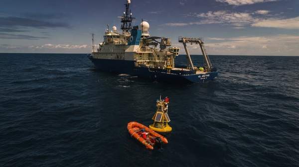
Ships extend that precision across space. Research cruises collect information about a specific ecosystem or area of interest, and NOAA's Ships of Opportunity programs, run by its Pacific Marine Environmental Laboratory and Atlantic Oceanographic and Meteorological Laboratory, have carried monitoring into remote regions—high-latitude waters, mid-basin stretches far from land—that are otherwise hard to reach. According to the program, these partnerships have greatly increased the spatial coverage of acidification monitoring worldwide.
The limitation is the mirror image of the satellite's: a buoy is a fixed point, and a cruise is a moving line. Direct sampling is precise and reliable, but, as the remote-sensing review puts it, field and in-situ methods are "inherently limited in spatial and temporal coverage and resolution." No number of buoys can blanket an ocean.
Comparing Ocean Acidification Monitoring Platforms
The table below contrasts the three platforms across the dimensions that matter for a monitoring program: how much ocean they see, how often they see it, what they actually measure, and where they fall short. Read it as a decision aid—large-scale, long-term tracking points to satellites; high-resolution local studies point to UAVs; continuous, direct chemical records point to in-situ instruments.
| Platform | Spatial Coverage | Temporal Resolution | Key Parameters Measured | Primary Limitation |
|---|---|---|---|---|
| Satellite | Global to large-scale, surface only | Frequent, regular, repeatable acquisition suited to long-term trends | Surface pH and atmospheric CO2; sea surface temperature and salinity; modeled air-sea CO2 fluxes, total alkalinity, particulate inorganic and organic carbon, calcification rates | Measurements are indirect, confined to the surface, and depend on algorithms whose confounding factors are major error sources; subsurface pH cannot be directly measured |
| UAV | Very high resolution (down to 8 cm in cited comparisons) over local areas | Flexible, on-demand acquisition for specific campaigns | Multispectral and hyperspectral water-quality parameters (demonstrated in inland waters; applied to ocean studies by analogy) | Constrained by flight duration, payload, weather, and intensive processing requirements; unsuited to continuous or large-scale monitoring |
| In-situ (buoys and ships) | Fixed points (buoys) or transects and survey areas (ships), including remote regions | Continuous—MAPCO2 buoy sensors sample pCO2 every three hours; cruises are episodic | Direct carbonate chemistry: pCO2, total alkalinity, pH | Precise but spatially sparse; coverage grows only through extensive deployment and partnerships |
A Multi-Platform Approach: Building a Comprehensive Picture
The platforms are not competitors; they are designed to correct one another's blind spots. The satellite algorithm depends on ship measurements for calibration, as the Caribbean demonstration showed. The buoy's three-hourly pCO2 record anchors the time dimension that a satellite's modeled snapshot cannot. The drone fills the resolution gap between them along a coast or reef. The Frontiers review frames this as a shift toward multi-source, multi-scale monitoring—fusing datasets from different platforms, as researchers tracking large lakes have done by combining Landsat and Sentinel-2 imagery, and matching sensor scale to the problem: coarse, regional-to-global sensors for large-scale long-term tracking, finer platforms for local dynamics.
For ocean acidification, that logic means satellites watch the basin, drones inspect the reef or bay, and buoys and ships supply the direct chemistry that makes everything else trustworthy. The remote-sensing review concludes that satellite observation will be an important tool in future acidification studies precisely because it complements, rather than replaces, the precise but sparse in-situ record.
Integrating Observations for a Clearer Ocean Future
To accurately track and understand ocean acidification, scientists must continue to integrate data from diverse monitoring platforms, combining the broad coverage of satellites, the localized detail of UAVs, and the precise direct measurements of in-situ instruments. No one platform can answer the question alone: satellites cannot see below the surface, drones cannot stay aloft, and buoys cannot be everywhere.
The measurable indicator of progress is concrete: the continued development and deployment of integrated multi-platform monitoring networks, and the publication of research that synthesizes data from these varied sources. Studies like the MODIS-Aqua carbonate analysis—satellite retrievals validated against decades of ship-based GLODAP measurements—are the template. Readers watching this field should look for exactly that: new missions and algorithms paired with expanded buoy networks and cruises, and papers that fuse them, because that integration, not any single instrument, is what turns scattered observations into a global picture of a changing ocean.
Sources
- The use of satellites in detecting and monitoring changes in ocean acidity levels - Ocean Acidification
- Remote-sensing observations relevant to ocean acidification — HERO
- MDPI
- Observing Ocean Acidification from Space — TOS
- Frontiers | From multi-scale observations to integrated applications: a review of remote…
- Monitoring - NOAA Ocean Acidification Program